
Fichier:Colonial Map Of Africa in 1930.png

Taille de cet aperçu : 644 × 600 pixels. Autres résolutions : 258 × 240 pixels | 515 × 480 pixels | 825 × 768 pixels | 1 099 × 1 024 pixels | 2 000 × 1 863 pixels.
Fichier d’origine (2 000 × 1 863 pixels, taille du fichier : 432 kio, type MIME : image/png)
Ce fichier et sa description proviennent de Wikimedia Commons.
Description
| Description |
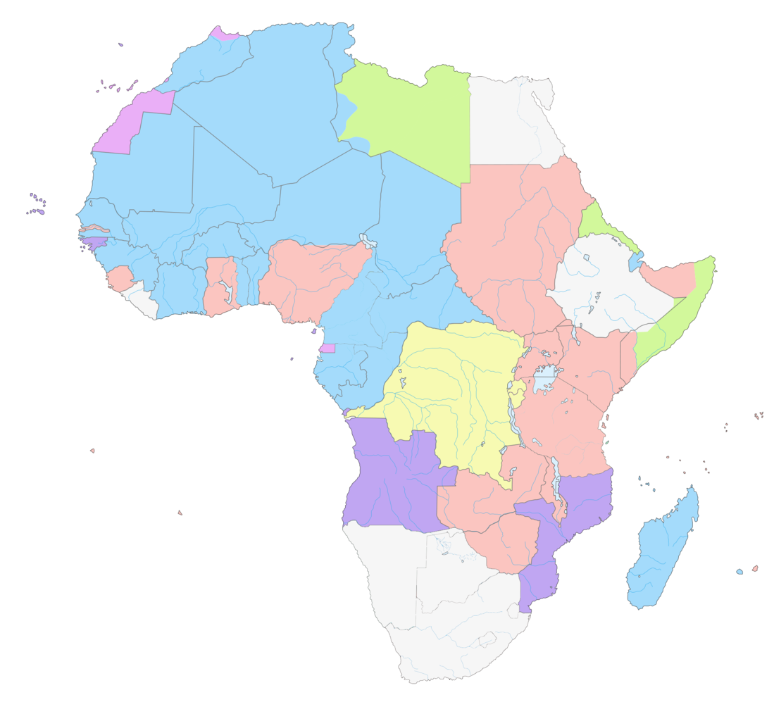
Français : Carte des Empires Européens en Afrique
English: Map of Colonial Africa in 1930
Belgium France Germany Great Britain Italy Portugal Spain Independent states |
| Date | 04/09/2010 |
| Source | Travail personnel |
| Auteur | Gd21091993 |
Conditions d’utilisation
| Moi, propriétaire des droits d’auteur sur cette œuvre, la place dans le domaine public. Ceci s'applique dans le monde entier. Dans certains pays, ceci peut ne pas être possible ; dans ce cas : J’accorde à toute personne le droit d’utiliser cette œuvre dans n’importe quel but, sans aucune condition, sauf celles requises par la loi. |
Historique du fichier
Cliquer sur une date et heure pour voir le fichier tel qu'il était à ce moment-là.
| Date et heure | Vignette | Dimensions | Utilisateur | Commentaire | |
|---|---|---|---|---|---|
| actuel | 2 septembre 2017 à 20:12 | | 2 000 × 1 863 (432 kio) | SUM1 | Fixed Ruanda-Urundi affiliation (Belgium) |
| 13 avril 2013 à 20:47 |  | 2 000 × 1 863 (432 kio) | Fry1989 | vandalism | |
| 13 avril 2013 à 18:02 |  | 2 000 × 1 863 (434 kio) | Mouh2jijel | Reverted to version as of 08:30, 13 April 2013 | |
| 13 avril 2013 à 16:42 |  | 2 000 × 1 863 (432 kio) | Omar-toons | Reverted to version as of 13:59, 28 March 2013 rv unjustified revert : Southern Cameroons to UK | |
| 13 avril 2013 à 10:30 |  | 2 000 × 1 863 (434 kio) | Mouh2jijel | Reverted to version as of 18:04, 8 April 2013 | |
| 13 avril 2013 à 08:16 |  | 2 000 × 1 863 (432 kio) | Omar-toons | Reverted to version as of 13:59, 28 March 2013 unjustified revert | |
| 8 avril 2013 à 20:04 |  | 2 000 × 1 863 (434 kio) | Mouh2jijel | Reverted to version as of 16:47, 7 April 2012 | |
| 28 mars 2013 à 15:59 |  | 2 000 × 1 863 (432 kio) | Omar-toons | Southern Cameroons to UK | |
| 28 mars 2013 à 15:30 |  | 2 000 × 1 863 (433 kio) | Omar-toons | Reverted to version as of 22:40, 16 July 2012 | |
| 29 janvier 2013 à 22:17 |  | 2 000 × 1 863 (434 kio) | Pacific kiribati | Reverted to version as of 16:47, 7 April 2012 |
Utilisation du fichier
Les 4 pages suivantes utilisent ce fichier :
Usage global du fichier
Les autres wikis suivants utilisent ce fichier :
- Utilisation sur ar.wikipedia.org
- Utilisation sur en.wikipedia.org
- Utilisation sur pl.wikipedia.org
- Utilisation sur sh.wikipedia.org
- Utilisation sur uk.wikipedia.org