
Fichier:Djerba Island.jpeg

Taille de cet aperçu : 600 × 600 pixels. Autres résolutions : 240 × 240 pixels | 480 × 480 pixels | 768 × 768 pixels | 1 024 × 1 024 pixels | 2 333 × 2 333 pixels.
Fichier d’origine (2 333 × 2 333 pixels, taille du fichier : 3,86 Mio, type MIME : image/jpeg)
Ce fichier et sa description proviennent de Wikimedia Commons.
Description
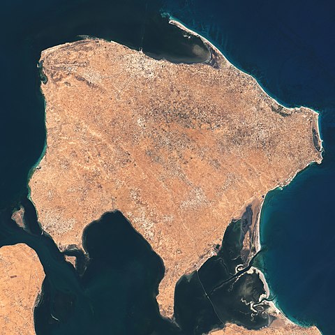
| Description | The Operational Land Imager (OLI) on Landsat 8 acquired these natural-color images of Ajim on May 4, 2020. |
| Date | |
| Source | https://earthobservatory.nasa.gov/images/146772/a-falcon-over-ajim |
| Auteur | NASA Earth Observatory images by Lauren Dauphin, using Landsat data from the U.S. Geological Survey. Story by Adam Voiland. |
Conditions d’utilisation
| Ce fichier provient de la NASA. Sauf exception, les documents créés par la NASA ne sont pas soumis à copyright. Pour plus d'informations, voir la politique de copyright de la NASA. | ||
 |
Attention :
|
Historique du fichier
Cliquer sur une date et heure pour voir le fichier tel qu'il était à ce moment-là.
| Date et heure | Vignette | Dimensions | Utilisateur | Commentaire | |
|---|---|---|---|---|---|
| actuel | 26 mai 2021 à 04:39 | | 2 333 × 2 333 (3,86 Mio) | StellarHalo | {{Information |Description=The Operational Land Imager (OLI) on Landsat 8 acquired these natural-color images of Ajim on May 4, 2020. |Source=https://earthobservatory.nasa.gov/images/146772/a-falcon-over-ajim |Date=4 May 2020 |Author=NASA Earth Observatory images by Lauren Dauphin, using Landsat data from the U.S. Geological Survey. Story by Adam Voiland. |Permission= |other_versions= }} Category:Satellite pictures by Landsat 8 Category:Satellite pictures of Tunisia Category:Djerba |
Utilisation du fichier
La page suivante utilise ce fichier :
Usage global du fichier
Les autres wikis suivants utilisent ce fichier :
- Utilisation sur en.wikipedia.org
- Utilisation sur mt.wikipedia.org
- Utilisation sur pl.wikipedia.org
- Utilisation sur th.wikipedia.org