
Fichier:Martis Creek Lake and Dam winter.jpg

Taille de cet aperçu : 800 × 527 pixels. Autres résolutions : 320 × 211 pixels | 640 × 422 pixels | 1 024 × 674 pixels | 1 500 × 988 pixels.
Fichier d’origine (1 500 × 988 pixels, taille du fichier : 743 kio, type MIME : image/jpeg)
Ce fichier et sa description proviennent de Wikimedia Commons.
| Description |
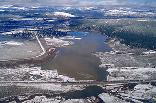
English: Aerial view of Martis Creek Lake and Dam in Nevada and Placer Counties, California, USA. The dam is located in Nevada County, approximately 5.5 miles (9 km) east of Truckee. The lake, when full, extends south along Martis Creek into Placer County. The lake lies next to the Truckee-Tahoe Airport, whose runway can be seen at far left in the picture. This photograph appears to have been taken in the winter when the water level was high. California State Route 267, also known as North Shore Road, runs across the picture at bottom. Boca Reservoir is visible at the top of the picture in the distance. View is to the north.
Coordinates: 39°19′16.86″N 120°6′46.53″W / 39.32135°N 120.112925°W |
|||
| Lieu | Nevada County, California, USA | |||
| Date | not specified or unknown | |||
| Source |
U.S. Army Corps of Engineers Digital Visual Library Image page Image description page Digital Visual Library home page |
|||
| Auteur | Michael Nevins, U.S. Army Corps of Engineers | |||
| Autorisation (Réutilisation de ce fichier) |
|
Historique du fichier
Cliquer sur une date et heure pour voir le fichier tel qu'il était à ce moment-là.
| Date et heure | Vignette | Dimensions | Utilisateur | Commentaire | |
|---|---|---|---|---|---|
| actuel | 5 mai 2007 à 19:02 | | 1 500 × 988 (743 kio) | DanMS | {{Information | Description = {{en|Aerial view of Martis Creek Lake and Dam in Nevada and Placer Counties, California, USA. The dam is located in Nevada County, approximately 5.5 miles (9 km) east of Truckee. The lake, when full, extends south along Ma |
Utilisation du fichier
La page suivante utilise ce fichier :
Usage global du fichier
Les autres wikis suivants utilisent ce fichier :
- Utilisation sur en.wikipedia.org
- Utilisation sur es.wikipedia.org
- Utilisation sur ja.wikipedia.org
- Utilisation sur pam.wikipedia.org
- Utilisation sur vi.wikipedia.org