
Fichier:PIA19154oppmarch2015.jpg

Fichier d’origine (3 360 × 2 537 pixels, taille du fichier : 1,45 Mio, type MIME : image/jpeg)
Ce fichier et sa description proviennent de Wikimedia Commons.
Description
| Description |
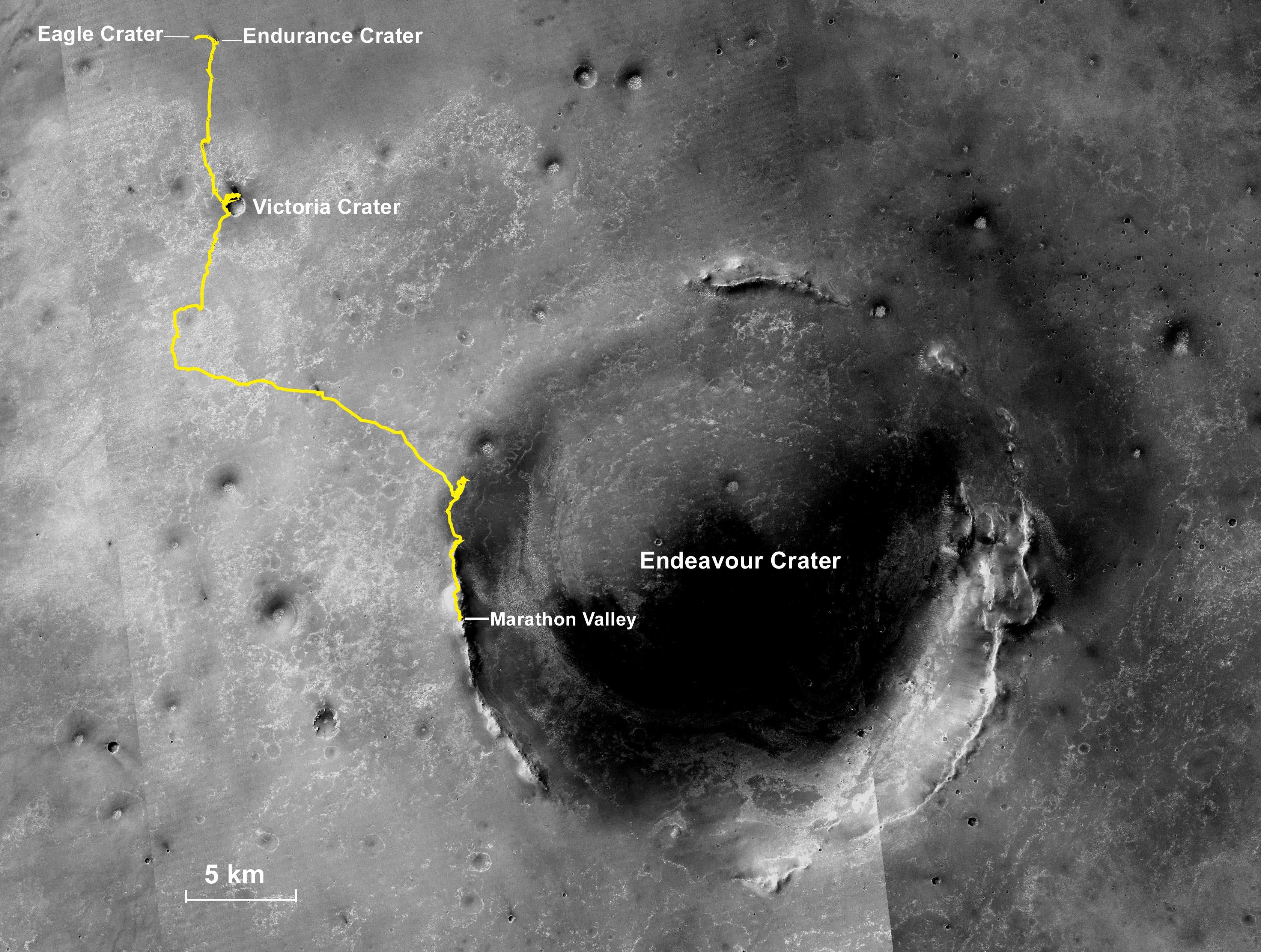
English: NASA's Mars Exploration Rover Opportunity, working on Mars since January 2004, passed marathon distance in total driving on March 24, 2015, during the mission's 3,968th Martian day, or sol. A drive of 153 feet (46.5 meters) on Sol 3968 brought Opportunity's total odometry to 26.221 miles (42.198 kilometers).
Olympic marathon distance is 26.219 miles (42.195 kilometers). The gold line on this image shows Opportunity's route from the landing site inside Eagle Crater, in upper left, to its location after the Sol 3968 drive. The mission has been investigating on the western rim of Endeavour Crater since August 2011. This crater spans about 14 miles (22 kilometers) in diameter. The mapped area is all within the Meridiani Planum region of equatorial Mars, which was chosen as Opportunity's landing area because of earlier detection of the mineral hematite from orbit. North is up. The base image for the map is a mosaic of images taken by the Context Camera on NASA's Mars Reconnaissance Orbiter. Earlier versions of this map, with other features labeled, are at PIA17758 and PIA18404. Opportunity completed its three-month prime mission in April 2004 and has continued operations in bonus extended missions. It has found several types of evidence of ancient environments with abundant liquid water. The Mars Reconnaissance Orbiter reached Mars in 2006, completed its prime mission in 2010, and is also working in an extended mission. This traverse map was made at the New Mexico Museum of Natural History & Science, Albuquerque. NASA's Jet Propulsion Laboratory, a division of the California Institute of Technology in Pasadena, manages the Mars Exploration Rover Project and the Mars Reconnaissance Orbiter for the NASA Science Mission Directorate, Washington. Malin Space Science Systems, San Diego, built and operates the orbiter's Context Camera. |
| Date | |
| Source | http://photojournal.jpl.nasa.gov/catalog/PIA19154 (image link) |
| Auteur | NASA/JPL-Caltech/MSSS/NMMNHS |
Cette image ou vidéo a été cataloguée par le Jet Propulsion Lab de la National Aeronautics and Space Administration (NASA) des États-Unis sous Photo ID : PIA19154.Ce bandeau n’indique rien sur le statut de l’œuvre au regard du droit d'auteur. Un bandeau de droit d’auteur est requis. Voir Commons:À propos des licences pour plus d’informations. Autres langues :
|
Conditions d’utilisation
| Ce fichier provient de la NASA. Sauf exception, les documents créés par la NASA ne sont pas soumis à copyright. Pour plus d'informations, voir la politique de copyright de la NASA. | ||
 |
Attention :
|
Journal des téléversements d’origine
| Date et heure | Dimensions | Utilisateur | Commentaire |
|---|---|---|---|
| 2015-04-11 12:02 | 3360×2537× (1516058 bytes) | Fotaun | http://photojournal.jpl.nasa.gov/jpeg/PIA19154.jpg )1.516 MB) http://photojournal.jpl.nasa.gov/catalog/PIA19154 Original Caption Released with Image: NASA's Mars Exploration Rover Opportunity, working on Mars since January 2004, passed marathon... |
Historique du fichier
Cliquer sur une date et heure pour voir le fichier tel qu'il était à ce moment-là.
| Date et heure | Vignette | Dimensions | Utilisateur | Commentaire | |
|---|---|---|---|---|---|
| actuel | 19 avril 2015 à 06:19 | | 3 360 × 2 537 (1,45 Mio) | Parcly Taxel | Transferred from en.wikipedia |
Utilisation du fichier
La page suivante utilise ce fichier :
Usage global du fichier
Les autres wikis suivants utilisent ce fichier :
- Utilisation sur ja.wikipedia.org
- Utilisation sur ko.wikipedia.org