
Fichier:S73-15171.jpg

Taille de cet aperçu : 451 × 599 pixels. Autres résolutions : 181 × 240 pixels | 361 × 480 pixels | 578 × 768 pixels | 771 × 1 024 pixels | 1 542 × 2 048 pixels | 6 176 × 8 204 pixels.
Fichier d’origine (6 176 × 8 204 pixels, taille du fichier : 6,19 Mio, type MIME : image/jpeg)
Ce fichier et sa description proviennent de Wikimedia Commons.
Description
| Description |
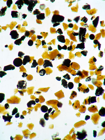
English: S73-15171 (4 Jan. 1973) --- These orange glass spheres and fragments are the finest particles ever brought back from the moon. Ranging in size from 20 to 45 microns (about 1/1000 of an inch) the particles are magnified 160 times in this photomicrograph made in the Lunar Receiving Laboratory at the Manned Spacecraft Center. The orange soil was brought back from the Taurus-Littrow landing site by the Apollo 17 crewmen. Scientist-astronaut Harrison H. "Jack" Schmitt discovered the orange soil at Shorty Crater during the second Apollo 17 extravehicular activity (EVA). This lunar material is being studied and analyzed by scientists in the LRL. The orange particles in this photomicrograph, which are intermixed with black and black-speckled grains, are about the same size as the particles that compose silt on Earth. Chemical analysis of the orange soil material has shown the sample to be similar to some of the samples brought back from the Apollo 11 (Sea of Tranquility) site several hundred miles to the southwest. Like those samples, it is rich in titanium (8%) and iron oxide (22%). But unlike the Apollo 11 samples, the orange soil is unexplainably rich in zinc -- an anomaly that has scientists in a quandary. This Apollo 17 sample is not high in volatile elements, nor do the minerals contain substantial amounts of water. These would have provided strong evidence of volcanic activity. On the other hand, the lack of agglutinates (rocks made up of a variety of minerals cemented together) indicates that the orange glass is probably not the product of meteorite impact -- strengthening the argument that the glass was produced by volcanic activity. |
| Date | |
| Source | http://spaceflight.nasa.gov/gallery/ |
| Auteur | NASA |
| Lieu de la prise de vue | | Voir cet endroit et d’autres images sur : OpenStreetMap |
|---|
Cette image ou vidéo a été cataloguée par l’un des centres de la National Aeronautics and Space Administration (NASA) des États-Unis sous Photo ID : S73-15171.Ce bandeau n’indique rien sur le statut de l’œuvre au regard du droit d'auteur. Un bandeau de droit d’auteur est requis. Voir Commons:À propos des licences pour plus d’informations. Autres langues :
|
Conditions d’utilisation
| Ce fichier provient de la NASA. Sauf exception, les documents créés par la NASA ne sont pas soumis à copyright. Pour plus d'informations, voir la politique de copyright de la NASA. | ||
 |
Attention :
|
Historique du fichier
Cliquer sur une date et heure pour voir le fichier tel qu'il était à ce moment-là.
| Date et heure | Vignette | Dimensions | Utilisateur | Commentaire | |
|---|---|---|---|---|---|
| actuel | 21 juin 2013 à 14:30 | | 6 176 × 8 204 (6,19 Mio) | Askeuhd | User created page with UploadWizard |
Utilisation du fichier
La page suivante utilise ce fichier :
Usage global du fichier
Les autres wikis suivants utilisent ce fichier :
- Utilisation sur ru.wikipedia.org
- Utilisation sur uk.wikipedia.org