
Fichier:Thermopylae & Artemisium campaign map.png

Taille de cet aperçu : 493 × 600 pixels. Autres résolutions : 197 × 240 pixels | 394 × 480 pixels | 822 × 1 000 pixels.
Fichier d’origine (822 × 1 000 pixels, taille du fichier : 1,04 Mio, type MIME : image/png)
Ce fichier et sa description proviennent de Wikimedia Commons.
Description
| Description |
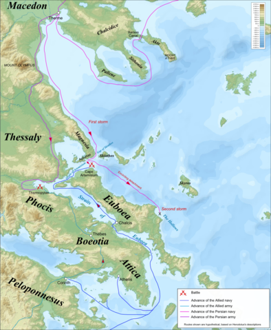
Campaign map for the Battles of Thermopylae & Artemisium (480 BC), based on the description of Herodotus. Imposed on a Bathymetic/Topographical map of the Aegean Sea.
|
| Date | (UTC) |
| Source | |
| Auteur |
|
| Autres versions | Œuvres dérivées de ce fichier : Termópilas y Artemisio - es.svg |
| Cette image a été retouchée, ce qui signifie qu'elle a été modifiée par ordinateur et est différente de l'image d'origine. Liste des modifications : Turned into a campaign map for the Battles of Thermopylae & Artemisium. L'image d'origine se trouve ici : Aegean Sea map bathymetry-fr.svg:
|
Moi, en tant que détenteur des droits d’auteur sur cette œuvre, je la publie sous les licences suivantes :
Ce fichier est sous licence Creative Commons Attribution – Partage dans les Mêmes Conditions 3.0 (non transposée), 2.5 Générique, 2.0 Générique et 1.0 Générique.
- Vous êtes libre :
- de partager – de copier, distribuer et transmettre cette œuvre
- d’adapter – de modifier cette œuvre
- Sous les conditions suivantes :
- paternité – Vous devez donner les informations appropriées concernant l'auteur, fournir un lien vers la licence et indiquer si des modifications ont été faites. Vous pouvez faire cela par tout moyen raisonnable, mais en aucune façon suggérant que l’auteur vous soutient ou approuve l’utilisation que vous en faites.
- partage à l’identique – Si vous modifiez, transformez, ou vous basez sur cette œuvre, vous devez distribuer votre contribution sous la même licence ou une licence compatible avec celle de l’original.

|
Vous avez la permission de copier, distribuer et modifier ce document selon les termes de la GNU Free Documentation License version 1.2 ou toute version ultérieure publiée par la Free Software Foundation, sans sections inaltérables, sans texte de première page de couverture et sans texte de dernière page de couverture. Un exemplaire de la licence est inclus dans la section intitulée GNU Free Documentation License. |
Vous pouvez choisir l’une de ces licences.
Journal des téléversements d’origine
This image is a derivative work of the following images:
- File:Aegean_Sea_map_bathymetry-fr.svg licensed with Cc-by-sa-3.0,2.5,2.0,1.0, GFDL
- 2009-02-08T00:35:16Z Sting 3750x4560 (3597775 Bytes) Correcting display bug - new try - step #2
- 2009-02-08T00:29:02Z Sting 3750x4560 (410188 Bytes) Correcting display bug - new try - step #1
- 2009-02-08T00:14:50Z Sting 3750x4560 (3740562 Bytes) Correcting display bug
- 2009-02-06T07:54:54Z Future Perfect at Sunrise 3750x4560 (3742390 Bytes) null edit, re-uploading to try to force display to be reset, background image wasn't displaying
- 2009-02-06T07:52:12Z Future Perfect at Sunrise 3750x4560 (3742390 Bytes) null edit, re-uploading to try to force display to be reset, background image wasn't displaying
- 2008-09-28T21:11:49Z Sting 3750x4560 (3742390 Bytes) Completely new background using ETOPO1 data ; new standard colors ; some additional labels
- 2007-11-27T13:16:40Z Sting 3750x4560 (4078448 Bytes) Elevation on Chios
- 2007-11-26T23:25:43Z Sting 3750x4560 (4078446 Bytes) correction
- 2007-11-21T22:42:53Z Sting 3750x4560 (4079234 Bytes) Additional sea names
- 2007-11-21T20:21:26Z Sting 3750x4560 (4078039 Bytes) Additional key
- 2007-11-21T19:10:35Z Sting 3750x4560 (4072878 Bytes) {{Information |Description=Bathymetric map in French of the [[:Category:Aegean Sea|Aegean Sea]], Mediterranean Sea |Source=Own work ;Raster relief background map : [http://www2.jpl.nasa.gov/srtm NASA Shuttle Radar Topography
Téléversé avec derivativeFX
Historique du fichier
Cliquer sur une date et heure pour voir le fichier tel qu'il était à ce moment-là.
| Date et heure | Vignette | Dimensions | Utilisateur | Commentaire | |
|---|---|---|---|---|---|
| actuel | 24 avril 2009 à 09:53 | | 822 × 1 000 (1,04 Mio) | MinisterForBadTimes | {{Information Campaign map for the Battles of Thermopylae & Artemisium (480 BC), based on the description of Herodotus. Imposed on a Bathymetic/Topographical map of the Aegean Sea. *UTM projection; WGS84 datum ; shaded relief<br/> *Scales:<br/> **Topograp |
Utilisation du fichier
Les 5 pages suivantes utilisent ce fichier :
Usage global du fichier
Les autres wikis suivants utilisent ce fichier :
- Utilisation sur azb.wikipedia.org
- Utilisation sur bg.wikipedia.org
- Utilisation sur cs.wikipedia.org
- Utilisation sur de.wikipedia.org
- Utilisation sur el.wikipedia.org
- Utilisation sur en.wikipedia.org
- Utilisation sur es.wikipedia.org
- Utilisation sur fa.wikipedia.org
- Utilisation sur hr.wikipedia.org
- Utilisation sur hyw.wikipedia.org
- Utilisation sur it.wikipedia.org
- Utilisation sur ka.wikipedia.org
- Utilisation sur ko.wikipedia.org
- Utilisation sur mk.wikipedia.org
- Utilisation sur nl.wikipedia.org
- Utilisation sur pl.wikipedia.org
- Utilisation sur ru.wikipedia.org
- Utilisation sur sh.wikipedia.org
- Utilisation sur sk.wikipedia.org
- Utilisation sur tr.wikipedia.org
- Utilisation sur vi.wikipedia.org
- Utilisation sur www.wikidata.org