Fichier:CEM-36-NE-corner.jpg
Le contenu de la page n’est pas pris en charge dans d’autres langues.
Une page de Wikipédia, l'encyclopédie libre.

Fichier d’origine(2 560 × 1 920 pixels, taille du fichier : 2,02 Mio, type MIME : image/jpeg)

Ce fichier et sa description proviennent de Wikimedia Commons.

Description

Description
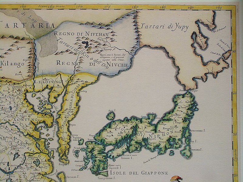
English: The north-eastern corner of a map of China (in Italian): "The Kingdom of China, presently called Catay and Mangin, divided into its principal provinces on a most precise map". This part shows includes Sea of Japan and Japan itself. However, neither the La Pérouse Strait nor the Strait of Tartary were known to the cartographer, and therefore Hokkaido and Sakhalin are all part of the mainland, populated by the "Yupi Tartars" (i.e. the "Fishskin Tartars" - the old Chinese name for the Nanai people and related groups). However, the eastern coast of Sakhalin, with Cape Aniwa and Cape Patience are already charted more or less correctly (thanks to a Dutch expedition in the 1640s). Sakhalin and Hokkaido are both represented as one peninsula in Yupi Tartars, and are separated from Japan by "Stretto di Züngar" (today Tsugaru Strait), between today Hokkaido and Honshu (Isola di Niphon). Probably in reference of the city of "Züngar" (today Tsugaru) shown in north of Honshu.
Italiano: "Il regno della China detto presentemente Catay e Mangin diuiso sopra le carte piu esatte nelle sue principali prouincie"
Date Originally published 1682; the copy at HKUST is a 1689 reprint.
Source
English: An antique map from the Special Collection "China in Maps" of the Hong Kong University of Science and Technology Library, reproduced by the HKUST Library in the book "China in European Maps", Hong Kong, 2003. ISBN 962-86403-9-9.
中文:一幅古代的地图从香港科技大学图书馆 ( 地圖中國 - 圖書館特藏展). 在书"China in European Maps", 香港, 2003. ISBN 962-86403-9-9.
Русский: Старинная карта из специальной коллекции Библиотеки Гонконгского научно-технического университета. Опубликована этой библиотекой в книге "China in European Maps" (Китай на европейских картах), Гонконг, 2003. ISBN 962-86403-9-9, тиражом 1000 экз. См. также каталог выставки, Special Collection "China in Maps".
Plate 36: "Il regno della China detto presentemente Catay e Mangin diuiso sopra le carte piu esatte nelle sue principali prouincie"
Auteur Giacomo Cantelli da Vignola (1643-1695), Giovanni Giacomo de Rossi (1627-1691)
Autorisation
(Réutilisation de ce fichier)
Ceci est une reproduction photographique fidèle d'une œuvre d'art originale en deux dimensions. L'œuvre d'art elle-même est dans le domaine public pour la raison suivante :
Public domain

Cette œuvre est également dans le domaine public dans tous les pays pour lesquels le droit d’auteur a une durée de vie de 100 ans ou moins après la mort de l’auteur.


Vous devez aussi inclure un modèle indiquant pourquoi cette œuvre est dans le domaine public aux États-Unis.
La position officielle de la Fondation Wikimedia est que « les représentations fidèles des œuvres d'art du domaine public en deux dimensions sont dans le domaine public et les exigences contraires sont une attaque contre le concept même de domaine public ». Pour plus de détails, voir Commons:Quand utiliser le bandeau PD-Art.
Cette reproduction photographique est donc également considérée comme étant élevée dans le domaine public. Merci de noter qu'en fonction des lois locales, la réutilisation de ce contenu peut être interdite ou restreinte dans votre juridiction. Voyez Commons:Reuse of PD-Art photographs.
Autres versions Entire map:
Annotations
InfoField
Cette image est annotée : Voir les annotations sur Wikimedia Commons

Légendes

Ajoutez en une ligne la description de ce que représente ce fichier

Éléments décrits dans ce fichier

dépeint

image/jpeg

2f9794ab254848c048b59f077ad1f0ee45ac1153

2 115 252 octet

1 920 pixel

2 560 pixel

Historique du fichier

Cliquer sur une date et heure pour voir le fichier tel qu'il était à ce moment-là.

Date et heureVignetteDimensionsUtilisateurCommentaire
actuel19 mars 2009 à 14:52Vignette pour la version du 19 mars 2009 à 14:522 560 × 1 920 (2,02 Mio)Vmenkov{{Information |Description={{en|1=The north-eastern cornet of a map of China (in Italian): "The Kingdom of China, presently called Catay and Mangin, divided into its principal provinces on a most precise map". This part shows includes Sea of Japan and Ja

Les 5 pages suivantes utilisent ce fichier :

Usage global du fichier

Les autres wikis suivants utilisent ce fichier :

Métadonnées